CAN THE TRANSPARK CONTAMINATE MAMMOTH CAVE?
Roger W. Brucker 1
ABSTRACT: The ITA (InterModal Transportation Authority), a development agency of Warren County, KY, spent more than $200,000 in 2001 and 2002 on advertising and publicity to persuade the public that the Graham Springs karst basin, a globally significant watershed, is indeed safe for the construction of a proposed 1620 hectare Trimodal Transpark. This industrial park and airport site is 13 km from the apparent edge of the Turnhole Spring karst basin, a headwater area of Mammoth Cave National Park. The developers have stated that the site of the proposed development is no different than "40% of the land east of Oklahoma which is located upon karst." However, this area is identified on a map by the Center for Cave and Karst Studies as being in the highest risk category for contamination, flooding, and collapse of any karst area in the state. The ITA claims that sinkholes developed 40 to 60 m above the low water stage can be readily detected and mitigated by dynamic compaction vs. continual surprise collapses due to construction drainage alterations. The ITA asserts that drainage in this karst can be controlled with plugs and synthetic membrane lined storm water retention ponds. However, local construction experience is that such methods often fail expensively due to unstable subgrade. The ITA claims that pollution will not occur because of the intended use of peat moss filters. However, this treatment has high initial and maintenance cost and may be adversely affected by the sinkholes. The ITA argues that flooding will not be a problem as the site is above the Barren River flood plain. However, periodic, severe sinkhole flooding is common in the area. The ITA claims that Mammoth Cave National Park groundwater cannot be harmed because the park is "nine miles uphill" from the Transpark site. However, there is proven karst basin communication locally in heavy rainfalls and the presence of a three-dimensional cave conduit set at all levels. The ITA has not ruled out contamination of Mammoth Cave's groundwater. The cost-benefit is the core of the value argument. Due to public opposition to this project, development of the Trimodal Transpark is now two years behind schedule.
1 KEEP Steering Committee, 1635 Grange Hall Road, Beavercreek OH 45432 brucker@graphtronics.net
INTRODUCTION
The ITA (InterModal Transportation Authority), a development agency of Warren County, KY, states that constructing the proposed 1620 hectare Trimodal Transpark in the globally significant Graham Springs karst basin will not degrade the protected groundwater of Mammoth Cave National Park (Wilbur Smith Associates 2001). This industrial park and airport site is 13 km from the apparent edge of the Turnhole Spring karst basin, a headwater area of Mammoth Cave National Park.
Mammoth Cave National Park contains the world's longest cave (Brucker and Watson 1976). Its underground waters are designated by the Kentucky Division of Water as Outstanding National Resource Waters, Tier III, into which no discharges may be permitted (Lambert 2003). The park is a UN World Heritage Site and Biosphere Reserve. The Central Kentucky Karst, in which Mammoth Cave is located, is one of the most studied karst regions of the world (Meiman et al. 2001b p.1). The park brings $116 million of revenue annually to the region and state (Carson 2001).
A review of the environmental problems facing Mammoth Cave National Park (Meiman et al. 2001b) focuses on the fragility of the park's groundwater and the fact that the headwaters of its drainage basin extend far beyond the protective boundaries of the park. Consequently, threats beyond the control of the National Park Service place the aquatic biota at risk. Culver and Sket (2000) term Mammoth Cave a "hot spot of underground biological diversity", including the federally endangered Kentucky Cave Shrimp (Palaemonias ganteri Hay) and other cave adapted animals. The park and local authorities have developed response procedures to trap and treat hazardous spills on I-65 6 km from the park in the same drainage basin (Olson and Schaefer 2001). This vigilance has been sharpened by a history of damaging spills. A tanker truck spill of gasoline saturated Logsdon River, an underground trunk stream, and wiped out the aquatic biota for a decade (Borden and Brucker 2000 pp. 222-225).
The ITA employed Wilbur Smith Associates, Law GIBB Group Inc., and Center for Cave and Karst Studies as their karst consultants. The ITA states that, based on existing data, effluent from the proposed Transpark cannot impact the groundwater of Mammoth Cave National Park because an intervening drainage divide precludes interbasin communication of groundwater (Crawford 2003 pp. 3,12). If this is incorrect, contamination has the potential to destroy a world treasure. According to White (2001), "The claim that any accidental contamination of the ground water system would affect only Graham Springs and its catchment area reflects a great and probably unjustified confidence in the ground water map prepared by J. F. Quinlan and J. A. Ray, first published in 1981." White further states: "In the geological evolution of the drainage system in the Mammoth Cave area, underground drainage to the Green River has been migrating westward�the rapidly enlarging Turnhole Spring basin captured a substantial portion of the eastern part of the Graham Springs basin, forcing the Graham Springs/Turnhole Spring divide westward to its present location" (White 2001).
This paper addresses six issues related to karst drainage in the context of the proposed Transpark, to aid in assessment of the potential impacts of this proposed development.
Is This Karst the Same as Karst Elsewhere (Hence Safe for Heavy Construction and Use)?
The ITA states that "approximately�40% of the U.S. east of Oklahoma is located upon karst," and hence the Transpark site is safe for construction (Crawford 2003 p. 4). Estimates vary as to what percentage of the U.S. is underlain by carbonate rock, but limestone bedrock is not interchangeable with karst. The map "Karst Hazard Assessment of Kentucky: Sinkhole Flooding and Sinkhole Collapse," shows that much of Warren County, site of the Transpark, is located in the moderate to highest risk categories for sinkhole flooding and collapse (Crawford and Webster 1986). Beck states that the hazard of sinkhole collapse at the Transpark site is "significant" (Beck 2002 pp. 4-5). Aley warns that "no runway could be threaded through the assemblage of buffer zones" needed because of the presence of substantial and numerous sinkholes throughout the proposed runway area (Aley 2002 p. 5). Discussion continues as to whether or not the Transpark site belongs in the moderate or high risk category, and there is real concern regarding potential collapse.
Part of the continuing controversy relates to whether a brittle formation, the Lost River Chert, is present, continuous, can act as an aquifer barrier, and is structurally competent (May and Kuehn 2003)2.
Are Sinkholes and Voids Easy to Detect and Mitigate (Hence Ensuring that the Transpark Site is Economically Feasible)?
The ITA states that voids developed in land 40 to 60 m above the low water stage can be detected easily and mitigated, and hence the Transpark site is
2 May and Kuehn challenge assertions by Crawford (2003): "The conclusions that the Lost River Chert will be an aquifer barrier, thereby protecting the underlying aquifers, is absolutely false. The chert is actually discontinuous and fractured. According to several geologists at the Kentucky Geological Survey who have just released the 30 x 60 Minute Beaver Dam Geological Quadrangle (2002), only the general stratigraphic level of the Lost River Chert is known. Their new map does not imply that the Lost River Chert is a continuous layer.
"Further claims of the Lost River Chert being a structurally strong layer and approximately 4 m thick is also false. According to the legend in the above mentioned geological map, the Lost River Chert is 'limestone and chert' and individual chert layers are no more than 30 cm thick. The ITA consultant has repeatedly painted a picture of 1) continuous chert, 2) impervious to water chert, and 3) an extremely thick chert all over the proposed site. He has purposed this without boring a single hole!" economically feasible for use by heavy industry and an airport (Crawford 2002 p. 30).
Bowling Green and Warren County have a well-documented history of expensive karst disasters, including flooding, pollution of caves, and costly sinkhole collapses (Crawford and Hoffman 1989). Bowling Green's approach to sanitary sewers has been to empty them into cave passages. Leakage of chemicals into the underground has produced explosive vapor and EPA Superfund cleanups. Warren County's present method of untreated stormwater disposal is to channel it to over 500 injection wells, 40 or more of which have caused collapse (Crawford and Hoffman 1989 pp. 58, 69). Based on this source, it can only be concluded that in the Bowling Green area, collapse is unanticipated, frequent, and expensive.
A more recent example is the Dishman Lane collapse on the south side of Bowling Green. Extensive mapping and microgravity research indicated two areas of void, and that State Trooper Cave extended diagonally beneath the proposed road (Crawford and Hoffman 1989 p. 104). City engineers apparently ignored this information and aligned the route to follow its original course. The road collapsed catastrophically into the cave in February of 2001, trapping several cars. The repair cost $1 million and took ten months. There are numerous other ongoing examples of karst collapse and inadequate engineering throughout Warren County (KEEP 2002b; Crawford and Hoffman 1989).
According to the ITA, the voids beneath the airport runways of the proposed Transpark are readily detected, and can be mitigated via responsible engineering procedures. The economic consequence of chronic or catastrophic collapse of an airport runway is high; Aley notes that sinkhole collapse in this context could result in "injury and loss of life" and that "sinkhole collapse is a common and expensive problem in this region of Kentucky" (Aley 2002, pp. 11, 4; Beck 2002 p.5). Responsible engineering has a very high price tag. In the realm of geological investigation, to date not a single borehole has been drilled or core examined at the proposed Transpark site, according to Crawford (2003) and media reports. Warren County's collapse history and inadequate engineering to date indicates cause for concern.
Can Long-Term Mitigation Be Reliably Based on Monitoring ?
The ITA states that drainage in this area can be controlled with sinkhole plugs and synthetic membrane lined retention ponds (Crawford 2002 pp. 3, 33-34). A survey of local construction experience indicates that such methods often fail due to unstable subgrade (KEEP 2002b p. 9; Aley 2002 p. 9; Beck 2002 pp. 5-6).
Additionally, at this site, these mitigation measures are subject to structural collapse risk as per the above discussion. Holding ponds, lined or not, sewer and utility lines, foundations, buildings and other infrastructure are not designed to last forever. The ITA needs to consider the 25 or 50 year replacement cost. Few doubt that many karst obstacles can be overcome if cost is no object.
The budget for the proposed replacement airport is $30 million. It calls for an allowance of $3 million to fix collapses and drainage accidents by dynamic compaction (Landrum & Brown, Inc. 2002). The ITA points out that other airports are constructed on karst (Wilbur Smith Associates 2001). Three of the four airports cited are built on less collapse-prone karst. Further, the ITA fails to mention airports where the annual collapse repair cost approaches $3 million (Wilbur Smith Associates 1983; Brucker 2001a; Brucker 2001b; see also Aley 2002 p.12; Beck 2002 p. 4).
If the drainage structures fail at the Transpark, industrial wastes and airport discharges can be transmitted in minutes to the underground environment. With no emergency response facilities planned for the Transpark, emergency responders would drive 13 km from Bowling Green. Pump and treat methods usually fail in karst regions. Pollutants may be trapped for years in this karst and suddenly remobilized by a heavy rain.
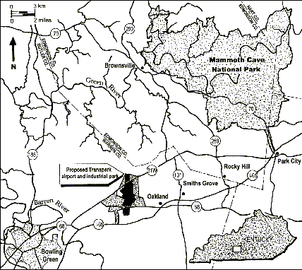
Figure 1. Central Kentucky Karst with proposed Kentucky TriModal Transpark. Map by Roger W. Brucker, KEEP.
Are Peat Moss Filters a Permanent Treatment For Hazardous Effluents?
The ITA asserts that pollution will not travel offsite because of the intended use of peat moss filters (Crawford 2002 p. 42). This treatment has high initial costs and maintenance costs and may be adversely affected by dynamic changes in the sinkholes.
Peat moss filters can be temporarily effective at trapping some contaminants (KEEP 2002b pp. 9-10). At issue here is their capacity to capture industrial chemicals, fuels, machinery cleaners, BTEX, anti-icing compounds and similar toxic spills effluent from the proposed airport, trucking, rail, and heavy industrial areas of the Transpark. The high construction and maintenance cost of filters and their short renewal/replacement life has not been budgeted, and they are vulnerable to the same structural shifting as other hard infrastructure.
The ITA has provided for mitigation of these failures by advocating construction of a storm sewer system to carry industrial effluent to the Barren River. The Bowling Green sewer system is facing federal stormwater planning and TMDL (the total maximum daily load of pollutants a waterbody can receive and still meet water quality standards) deadlines and requirements. Although the Warren County Planning and Zoning Ordinances prohibit construction of tank farms on this karst because of the demonstrated hazard when the tanks leak, the ITA calls for a concrete pit to contain such tanks at the Transpark site (Crawford 2002 pp. 33-34, 41).
Discussion must continue regarding the feasibility, long-term reliability and costs of these proposed measures.
Is There Flood Danger To the Transpark Site?
The ITA states that flooding at the proposed Transpark would not be a problem as the site is above the Barren River flood plain (Crawford 2002 pp. 17-19). This assessment ignores the fact that severe sinkhole flooding is common in the Bowling Green area, and on the proposed Transpark site (KEEP 2002b Appendix B). A discussion of this problem, with associated expensive losses due to flooding and retention pond collapse, is presented in Crawford and Hoffman 1989 pp. 41-49. This document calls for a comprehensive survey to establish the 100-year flood level around sinkholes. Aley notes that until the issues of potential flooding are understood and resolved, financial risk assessment of this site is incomplete (Aley 2002 p. 1). Beck cautions against underestimated potential flood damage and costs (Beck 2002 pp. 7-8).
Can The Transpark Contaminate Mammoth Cave?
The ITA states that Mammoth Cave National Park groundwater cannot be degraded by Transpark effluent, because the park is "nine miles uphill" and the drainage divide is "very similar to a surface divide where water flows down one side of a mountain range or the other" (Crawford 2002 p. 10; ITA press releases, 2002). Concern remains that this ironclad assurance is neither true nor scientifically proven, and cannot be guaranteed. It is proven that there is karst interbasin groundwater communication locally as a result of heavy rainfall, and that the bedrock between the proposed Transpark and the Mammoth Cave National Park boundary is characterized by a three-dimensional set of cave tubes, canyons, partings, and vertical shafts at all levels, from the top of the Ste. Genevieve limestone to the base of the St. Louis limestone (Brucker 1966; Brucker et al. 1972; Crawford and Hoffman 1989; White and White 1989; White et al. 1970).
Should the ITA's assurances prove false, chronic or catastrophic impacts on Mammoth Cave's water quality could be tragic and long-lasting, in violation of these waters' Tier III protected status and of state and federal cave protection laws.
In a July 2001 letter to the ITA, 18 karst scientists asked the ITA to conduct a comprehensive study of groundwater movement at high and low stages and including storm pulse data: "Based on our understanding of the evidence, it is certain that hydrologic communication does take place between the basin in which the KTT is sited and an important Mammoth Cave National Park groundwater basin. What is NOT certain are the conditions under which spillover and seepage will occur and the probable risk. Mammoth Cave National Park is too valuable to allow speculation about this issue to remain unresolved�Therefore, we strongly urge that the ITA undertake a comprehensive, professional, hypothesis-based investigation of the circumstances and characteristics of groundwater movement in the area between the KTT and Mammoth Cave National Park to put all doubt and conjecture to rest. We understand the FAA requires a full-fledged EIS study before proceeding, and that the ITA has agreed to conduct such a study. The rigorous hydrological assessment using piezometric methods, storm pulse data, and modeling high and low stage scenarios as described in this letter must be part of that study" (Brucker et al. 2001). To date, the author is unaware of any research carried out by the ITA that examines "high and low stage" and "storm pulse" conditions for interbasin groundwater communication. In fact, two hurricane flood events were not dye traced during 2002, according to the Executive Summary of the report prepared in response to the 18 scientist letter (Crawford 2003).
Numerous case studies are cited below as evidence that communication of groundwater takes place across basin boundaries in this area, at various stages from below base level to a 40 m rise in the caves above the base level river pool. These examples characterize drainage spillover at various stages in the Mammoth Cave area.
1. A dye trace by Quinlan, Ewers and Ray was conducted in Little Sinking Creek, a well-known karst swallow, during a high water stage. The creek flowed across Rocky Hill-Hayes Road and into a sinkhole where the dye was introduced to the underground system. Dye emerged at two locations, Turnhole Spring on the Green River, which is part of the Mammoth Cave drainage basin, and Graham Springs on the Barren River. This dye trace is mentioned in the ITA's published Environmental Assessment on pages 4-36 and 4-50, 51, and demonstrates a high stage hydrological communication between the two basins (Quinlan et al. 1983; White and White 1989 pp. 65-104; Wilbur Smith Associates 2001).
2. A dye trace by Quinlan, Ewers and Ray was conducted in a sinkhole about one mile north of Rocky Hill, KY. The dye emerged at two locations, Turnhole Spring on the Green River, which is part of the Mammoth Cave drainage basin, and Graham Springs on the Barren River. This dye trace, mentioned in the ITA's published Environmental Assessment on pages 4-36 and 4-50, 51, demonstrates there is a hydrological communication between the basins (Quinlan et al. 1983; White and White 1989 pp. 65-104; Wilbur Smith Associates 2001).
3. A dye trace from Madison Spring by Quinlan as cited by Crawford and Hoffman: "During base flow conditions water from Madison Spring continues to flow to two groundwater basins, Graham Springs and Turnhole Spring. The extent to which these two groundwater basins overlap is not known, but discussed by Quinlan (1976), their common boundary has been proven to shift during floods" (Crawford and Hoffman 1989 p. 29).
4. Multiple dye traces have been conducted by Quinlan, Ewers and Ray and confirmed by Meiman. Dye was introduced into the underground Logsdon/Hawkins River in the Turnhole Spring drainage basin. The dye emerged from Turnhole Spring and from Roaring River/Echo River Spring during a rise of >3m of Logsdon/Hawkins River. The spillover water passed through an overflow route to Roaring/Echo River. These dye traces demonstrate a spillover from one basin to another within Mammoth Cave (Meiman and Ryan, 1993).
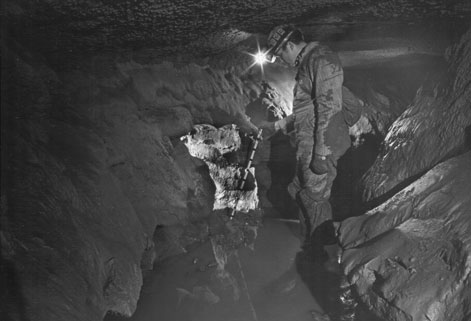
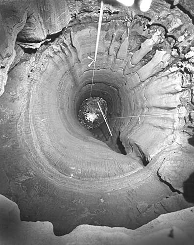
Figure 2. Groundwater conduits in the Central Kentucky Karst restrict flow during heavy rains. Stage rises in the cave may exceed two times the river stage rise. Explorer points to a vertical shaft drain confluence from a shaft located about 800 m upstream in the tributary. That shaft is 12 m in diameter and 52 m high, with abandoned drains at several levels in its vertical walls. Flood water can drown the former drains. Photo from the author's collection.
Figure 3. A typical vertical shaft in the Central Kentucky Karst showing abandoned drains at several levels. Stage rises in the caves may reactivate the drains and conduct water to other locations than the active low water drain. Photo from the author's collection.
5. A dye trace by Meiman during low stage conditions has demonstrated continuous leakage from the Logsdon/Hawkins River into the Roaring River/Echo River basin regardless of the river stage. This preliminary finding demonstrates that continuous leakage between basins is possible (Meiman et al. 2001a).
6. An observed drainage divide spillover: James Borden describes a water backup and spillover between drainage basins in Roppel Cave, a part of Mammoth Cave. A stream in Arlie Way crosses the passage at an elevation of approximately 168 m MSL. This unnamed stream was dye traced by Quinlan to emerge from Pike Spring at a pool elevation of 128 m. A second stream is located near Cumquat Causeway near the south end of Arlie Way. Its elevation is about 168 m, and it was followed by explorers and dye traced to Logsdon River, that emerges from Turnhole Spring. Several flood rises of a half meter or more in this second stream were observed by Borden to back up and drain through the stream that emerges from Pike Spring. Borden notes that a corresponding rise in the Pike Spring tributary would be captured by Logsdon River and emerge at Turnhole Spring, 18 km downstream from Pike Spring. This basin spillover is located 40 m above the river base level (Borden, 2003).
A review of additional comments and observations further delineates the need for better study of this issue. In recent statements, White (2001), Palmer (2001), Poulson (2001), Barr (2002), Ewers (2002), Meiman (2002), Currens (2002), Hess (2002), Wells (2002), Watson (2002) have each said that low water drainage basin boundaries shift with heavy rains, and that high water dye tracing, up-to-date dye tracing, and/or modeling is necessary to rule out contamination of the Mammoth Cave groundwater from the Graham Springs basin (see also Brucker et al. 2001).
Crawford states that the Graham Springs basin probably does spill over into the adjacent Poorhouse Spring basin during high water (Crawford 2003 p. 22). As shown on the Quinlan and Ray groundwater map (1981; Ray and Currens 1998) the low water basin divide between the two is within 6 m of the elevation of the low water basin divide between the Graham Springs basin and Turnhole Spring basin.
Crawford presents data and discussion based on stage recorders in two caves and the Hagen well to conclude that the groundwater gradient is always toward Graham Springs in the Graham Springs basin (Crawford 2002 p. 15; 2003 p. 8). He argues that level gage data rule out seepage, leakage, or spillover. This conclusion was challenged by KEEP (KEEP 2002a) and by others including Ewers (2002).
The challenge by Ewers is instructive. His five concerns include 1. The quality of the Quinlan and Ray 1981 data; 2. Misinterpretations of some of the dye traces due to rhodamine WT dye degradation and possible visual confusion with fluorescein dye; 3. The Hagen well does not represent the true elevation of the groundwater divide, and all other well data from the upper portions of the Graham Springs basin may be similarly suspect; 4. Much of the 18 km common northern and eastern boundary of the Graham Springs basin and the Turnhole Spring basin is unknown; and 5. Spills from increased traffic generated by the Transpark will increase the contamination risk (Ewers, 2002). One problem with a single direction flow hypothesis in this situation is that the highest of the three points, Hagen well, may only indicate local epikarst conditions. According to Ewers, "The Hagen well, which is a pivotal point in Dr. Crawford's analysis of the potential for flow reversals, was a private water supply well, not a well driven into the master conduit system. The monitoring points to the west in the Graham Springs basin are so positioned. Thus, the Hagen well gives absolutely no assurance that it represents the true elevation of the groundwater divide. The true level may be significantly lower and more easily overcome. Indeed, all of the wells in the upper portions of the Graham Springs basin suffer from this same problem. They represent water levels only in the immediate vicinity of the well. A thesis study by a former graduate student, David Johnson, confirms the truth of my analysis" (Ewers, 2002).
Crawford's argument for the safety of Mammoth Cave from spillover contamination rests on the validity of the hypothesis that this divide behaves as a normal fluvial divide in a nonkarst setting. For this hypothesis to be credible one would need to find evidence of an impenetrable divide with respect to groundwater, whether or not one accepts the Quinlan and Ray (1981) tentative conclusion of the location and height of the divide. One would need to rule out dynamic shifts in divide locations in the face of documented evidence that such shifts are numerous and can occur at elevations up to twice the rise in the base level stream stage (see also Quinlan and Ewers, 1981).
If the Quinlan and Ray 1981 data about groundwater levels is accurate, a 21 m rise in water at the Transpark site would spill over the 146 m divide. Crawford reports that 27 m and 31 m rises have been recorded at Mill Cave and Wolf Sink, near and on the Transpark site (Crawford 2002 p. 15).
CONCLUSION
In conclusion, none of the evidence cited by the ITA rules out the possible contamination of Mammoth Cave groundwater by Transpark effluent. The necessary research called for by 18 karst scientists in 2001 has not been carried out, and arguments from inconclusive or inadequate data leave the issue of Mammoth Cave groundwater contamination in the realm of guesswork. It is not up to the opponents of the Transpark to prove that Mammoth Cave is threatened. It is the obligation of the ITA and its advisors to prove that the development is safe and to produce conclusive evidence that it will not contaminate.
The ITA's documents cite hoped-for Transpark benefits, such as new high tech jobs (estimates vary between 250 and 7,500), a chance to bring off a model development on karst, and a "pay its own way" project (ITA 2002). However, the ITA's projected cost for the project seems low: they have budgeted $30 million to construct the replacement airport while the FAA has estimated $150 million (Kiernan 2001).
Transpark opponents cite no benefits, and point to the threat to Mammoth Cave National Park's groundwater and aquatic biota, as priceless and irreplaceable if lost. It might be argued that contamination of the lowest level of the cave would not jeopardize tourist visits to the cave, even if it were in violation of state and federal law. However, visits to nearby Hidden River Cave and Lost River Cave were impossible until the early 1990s due to unhealthy and odoriferous groundwater contamination (Shipley 2001). Transpark opponents also argue that the mitigation costs for construction and maintenance of facilities on this unstable karst are likely to be higher than budgeted, all to be paid for with taxpayers' funds (KEEP 2002a,b).
Numerous lessons may be learned from the ongoing Transpark conflict. Professionals should advise clients not to ignore criticism or presume that their own experts are the only knowledgeable technical observers. Any perception that a client is attempting to avoid an EIS, withhold adverse comments, or exclude the public from the input process is likely to be seen by opponents as tacit evidence that the developer has something to hide. Characterizing critics as "outsiders" and "economic terrorists" may backfire. If a project threatens a national park, the arising nationwide opposition and challenges can tie up the project for years and increase its potential cost beyond any benefit. It may be arguable which of these lessons is most important, but there is no doubt that some combination of them has set back the Transpark construction timetable at least two years.
REFERENCES
Aley, T. (2002). "Comments in full from Risk Analysis." Reprinted as Appendix
E in KEEP (2002b).
Barr, T.C. (2002). "Statement." KEEP Perspective 1, Oakland, KY.
Beck, B. (2002). "Comments in full from Risk Analysis." Reprinted as Appendix
F in KEEP (2002b).
Borden, J. (2003). Personal communication. Feb. 9.
Borden, J., and Brucker, R.W. (2000). Beyond Mammoth Cave, SIU Press, Carbon-
dale IL.
Brucker, R.W. (1966). "Truncated cave passages and terminal breakdown in the Cen-
tral Kentucky Karst," National Speleological Society Bulletin 28(4), 171-178.
Brucker, R.W. (2001a). "Response to Environmental Assessment for the Proposed
Airport Kentucky Trimodal Transpark." KEEP Perspective 1. May.
Brucker, R.W. (2001b). "Airport sinkholes cost taxpayers millions: ITA consultant
was unable to fix drainage problems in Pennsylvania."
www.rogerbrucker.com/airportsinkholes.html
Brucker, R.W. et al. (2001). "Letter to Dan Cherry, ITA." Signed by 18 concerned
scientists regarding impact of the Transpark on the Mammoth Cave drainage. July.
Brucker, R.W., Hess, J.W., and White, W.B. (1972). "Role of vertical shafts in
movement of ground water in carbonate aquifers." Ground Water 10(6), 5-13.
Brucker, R. W. and Watson, R.A. (1976). The longest cave, Alfred E. Knopf, New
York, republished 1987 by Southern Illinois University Press, Carbondale, IL.
Carson, V. (2001). Personal communication.
Currens, J. (2002). "Comments on 'Site evaluation and design assistance for the
proposed Kentucky Trimodal Transpark, preliminary report based upon existing
data only.'"May.
Culver, D., and Sket, B. (2000). "Hotspots of subterranean biodiversity in caves and
wells." J. Cave and Karst Studies, 62 (1),11-17.
Crawford, N. (2002). "Site evaluation and design assistance for the proposed
Kentucky Trimodal Transpark, preliminary report based upon existing data
only." CCKS, Bowling Green KY.
Crawford, N. (2003). "Final report: executive summary proposed Kentucky Tri-
modal Transpark." CCKS, Bowling Green KY.
Crawford, N. and Webster, J. (1986). "Karst Hazard Assessment of Kentucky:
Sinkhole Flooding and Sinkhole Collapse." Map. CCKS, Bowling Green, KY
Crawford, N. and Hoffman, W. (1989). "The karst landscape of Warren County."
Warren County Comprehensive Plan Technical Volume. Bowling Green, KY.
Ewers, R. (2002). "Comments on Quinlan, Ewers, Ray dye trace research." Re-
printed as Appendix C in KEEP (2002b).
Hess, J. (2002). "Statement." KEEP Perspective 1, Oakland, KY.
Intermodal Transportation Authority. (2002)."Vision." Brochure.
KEEP (2002a). "On 'Site evaluation and design assistance for the proposed Ken-
tucky TriModal Transpark.'" KEEP Perspective 1. Karst Environmental Educa-
tion & Protection. Oakland, KY.
KEEP (2002b). "On 'Risk analysis for the proposed relocation of the Bowling
Green-Warren County Regional Airport.'" KEEP Perspective 2. Karst Environ-
mental Education & Protection. Oakland, KY.
Kiernan, L. (2001). "Memo, June 6, 2001." Federal Aviation Administration. Re-
printed as Appendix D in KEEP (2002b).
Lambert, H. (2003). "Keeping Kentucky's waters clean: local antideg battle will
have national impact." Kentucky Newstreams, March, 3.
Landrum & Brown Inc. (2002). "Risk analysis study for the proposed relocation
of the Bowling Green-Warren County Regional Airport."
May, Michael T. and Kuehn, K.W. in prep. (2003). "A mammoth problem in Kentucky? earth system science input limited for proposed Kentucky Trimodal Transpark near Mammoth Cave."
Meiman, J. and M.T. Ryan. (1993). "The Echo River-Turnhole Bend overflow
route." CRF Newsletter, 21(1).
Meiman, J., Groves, C. and Herstein, S. (2001a). "In-cave dye tracing and
drainage divides in Mammoth Cave karst aquifer, Kentucky." Proceedings, U.S.
Geological Survey Karst Interest Group, St. Petersburg, FL, 179-185.
Meiman, J., Lambert, H., and Brucker, R.W. (2001b). "Management issues and
threats to the longest cave." Proceedings, 15th National Cave and Karst Man-
agement Symposium, Tucson, AZ, 75.
Meiman, J. (2002). "Review of 'Site evaluation and design assistance for the pro-
posed Kentucky Trimodal Transpark, preliminary report based upon existing
data only.'" Mammoth Cave National Park, May.
Olson, R. A., and Schaefer, J.L. (2001). "Planned spill retention and runoff filtra-
tion structure on Interstate 65." Proceedings, 15th National Cave and Karst Management Symposium, Tucson, AZ, 75.
Palmer, A. N. (2001). "In reference to the proposed Kentucky Trimodal Transpark."
January and May letters to the ITA. Reprinted in Appendix B in KEEP (2002a).
Poulson, T.L. (2001). "In reference to the proposed Kentucky Trimodal Transpark."
August letter to Dan Cherry, ITA. Reprinted in Appendix B in KEEP (2002a).
Quinlan, J. F., and Ewers, R.O. (1981). "Hydrogeology of the Mammoth Cave region,
Kentucky." GSA Cincinnati '81 Field Trip Guidebooks, T.G. Roberts, ed., Ameri-
can Geological Institute, Washington, D.C., 3, 457-495.
Quinlan, J. F. and Ray, J. (1981). "Map of groundwater basins, surface drainage, ma-
jor caves, flow routes, the potentiometric surface, and an index to the topographic
maps in the Mammoth Cave Region south of the Green River." Friends of the
Karst, Mammoth Cave, KY.
Quinlan, J.F., Ewers, R.O., and Ray, J.A. (1983). "Groundwater hydrology and
geomorphology of the Mammoth Cave Region, Kentucky." Field Trip Guide,
The Geological Society of Kentucky.
Ray, J.A. and Currens, J. (1998). "Mapped karst groundwater basins in the Beaver
Dam 30 x 60 Minute Quadrangle." Kentucky Geological Survey, Map and Chart
Series 19. Lexington, KY.
Shipley, S. (2001). "A clean river now runs through it." National Wildlife, 39(9), 36.
Watson, R.A. (2002). "Statement." KEEP Perspective 1, Oakland, KY.
Wells, S.G. (2002). "Statement." KEEP Perspective 1, Oakland, KY.
White, W.B. (2001). "Commentary on Environmental Assessment for the proposed
Kentucky TriModal Transpark." Reprinted in Appendix B in KEEP (2002a).
White, W.B., Watson, R.A., Pohl, E.R., and Brucker, R.W.(1970). "The Central Ken-
tucky Karst." Geographical Review 60, 88-114.
White, W. B. and White, E.L. (1989). Karst hydrology - concepts from the Mammoth
Cave area. Van Nostrand Reinhold, New York.
Wilbur Smith Associates (1983). "Report on Capital City Airport."
Wilbur Smith Associates (2001). "Environmental Assessment for the proposed
airport, Kentucky TriModal Transpark." February 16.
Geotechnical Special lPublication No. 122
Sinkholes and the Engineering and Environmental Impacts of Karst
Edited by Barry F. Beck
ASCE, Geo Institute and National Groundwater Association
In the section "The Central Kentucky Karst"
Brucker, Roger, W., 2003, Can the Transpark Contaminate Mammoth Cave?, p. 361-374